Weather Radar Explained: How Pilots See Storms Ahead
Airborne weather radar is a radar in the nose of an aircraft that detects rain, hail and thunderstorms ahead and shows them to the pilots in colour, so they can fly around the worst weather.
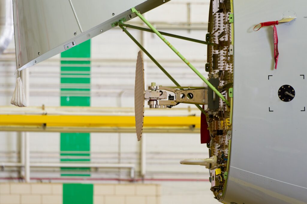
Weather radar is a radar installed in the nose of an aircraft that detects precipitation ahead, such as rain and hail, and shows it to the pilots on their navigation displays. Because thunderstorms contain heavy rain, the radar shows where the storms are, so the crew can plan a route around them instead of flying through severe turbulence, hail and lightning.
How it works
A flat antenna behind the nose cone, the radome, sends out short pulses of microwave energy and listens for the echoes. Large water droplets reflect much more energy than small droplets or dry ice crystals, so the strength of each echo indicates how heavy the rain is. The antenna scans from side to side, and the result is drawn on the display as a colour map:
- Green: light precipitation
- Yellow: moderate precipitation
- Red: heavy precipitation, likely a strong storm cell
- Magenta: very heavy precipitation, or turbulence on radars that can measure it
Pilots can change the tilt of the antenna up or down and the gain (sensitivity). Tilt matters: a storm’s strongest echoes are usually at lower and middle levels, so an antenna pointed too high can look over the top of a dangerous cell. Modern radars, such as those fitted to the Boeing 787 and Airbus A350, scan automatically at several angles, remove echoes from the ground and estimate how high each storm reaches.
Extra modes
Many airliner radars also have a turbulence mode, which uses the Doppler effect to spot fast-moving water droplets inside storms, and a predictive windshear mode, which looks for the wind pattern of a microburst during take-off and approach. You can read how those warnings work in our article on windshear detection.
Limits
Weather radar sees water, not air. It cannot detect clear-air turbulence, and dry hail or ice crystals at high altitude can give weak echoes even near a severe storm. Heavy rain close to the aircraft can also absorb the radar energy, hiding a storm behind it. Pilots therefore combine the radar picture with forecasts, reports and what they see outside, and they give strong storms a wide berth: FAA guidance advises avoiding severe thunderstorms by at least 20 nautical miles.
Frequently Asked Questions
Where is the weather radar on an airliner? Behind the pointed nose cone, called the radome, which is made of a material that lets radar waves pass through.
Can weather radar see turbulence? Only turbulence that contains rain, using the Doppler mode. It cannot see clear-air turbulence.
Does weather radar show clouds? Not ordinary clouds. It shows precipitation, which is why a storm without heavy rain can be hard to see.
Related terms: EFIS displays and EGPWS/TAWS.
References
- FAA Aviation Weather Handbook (FAA-H-8083-28), chapter on thunderstorms
- FAA Aeronautical Information Manual, chapter 7, section 1: Meteorology
- FAA Aviation Maintenance Technician Handbook – Airframe (FAA-H-8083-31), chapter on communication and navigation (weather radar)
Start the discussion
Commenting on this term: Weather Radar Explained: How Pilots See Storms Ahead